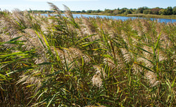
In 2019 FOSM will work with partners to develop a strategy and secure funding for implementing the report recommendations. Learn more about fighting Phragmites, and what the results of months of testing have proben to us by clicking the file below! A HUGE thank you to Normandeau Associates, Inc for helping FOSM with the testing, and pulling of this report.
Our new document available for download called "Stream Crossing Survey of the Scarborough Marsh Watershed". This survey was put together by Friends of Scarborough Marsh board member Steve Pinette. The compiled data from this report will be used by the Friends of Scarborough Marsh to help guide future efforts related to safeguarding and improving the ecologic health of the Marsh.
"GAP TRACKS" PROJECT TO HELP SCIENTISTS ASSESS WILDLIFE USE OF EASTERN TRAIL in the NONESUCH RIVER CORRIDOR Friends of Scarborough Marsh board member and UNE professor, Dr. Noah Perlut, has launched a new study, GAP Tracks Project, to document the wildlife community along the "GAP" section of the Eastern Trail currently under construction in the Nonesuch River area of the Scarborough Marsh. "The digital trail cameras, which went online in late February this year, will help scientists evaluate the wildlife community before, during, and after construction of the trail segment," said FOSM president, Stephanie Smith. "We're very pleased to be one of the sponsors of this study, and we're looking forward to seeing the data as the study progresses." Wildlife cameras have already captured several glimpses of animals in the area, including opossum, gray fox, and turkeys. Videos are posted to FaceBook at FB.me/GapTracks and details about the GAP Tracks project may be found online at blog.une.edu/perlutlab/. Students at UNE and Scarborough High School will be working with Dr. Perlut to evaluate the data. Photos will be scored to determine which are the best ones, and students will identify what animals were present and pose questions about wildlife and human use of the trail.
The public is invited to follow the research project online, and encouraged to add comments and questions, too. "It's a wonderful opportunity for people to learn more about this area of the marsh," said Smith, "and the more who tune in to watch what the cameras are seeing, the better." The Perlut Lab focuses on how human habitat management effects the ecology and evolution of diverse species. "This section being monitored is highly relevant to the ecology of Scarborough Marsh because it includes important headwaters of the Nonesuch River," explains Dr. Perlut, "and its adjacent forest serves as a movement corridor for mammals, amphibians and birds." This study is jointly funded by the Friends of Scarborough Marsh and the University of New England, in partnership with the Eastern Trail Alliance, Maine Department of Inland Fisheries and Wildlife, and the Town of Scarborough. As global temperatures rise, increasing the likelihood of more unpredictable weather patterns and severe tides, a major blizzard or flood could inundate low-lying coastal land. For a coastal community such as Scarborough, which is home to the largest contiguous marsh system in the state. The impact on Scarborough Marsh can be seen on the Maine Geological Survey’s interactive map. The MGS map shows the effects of rising sea levels across coastal areas of the state, using measurements from the highest tide of 2015, and factoring in increases of 1 to 6 feet based on storm-surge scenarios. The impact of sea level rise on property and roads is expected to be considerable as well. Peter Slovinsky, a marine geologist with the Maine Geological Survey and current chair of the Scarborough Conservation Commission, believes adopting a plan of action is not an option, it’s a necessity. >>Read more in the Leader / >> Read more in the Forecaster Related story in the Bangor Daily News, Crab invasion Heralds Sea Level Rise
A group of wildlife researchers will meet with the U.S. Fish and Wildlife Service in September to discuss a conservation plan for the saltmarsh sparrow. Studies show a sharp decline in their numbers in the last 15 years due largely to habitat loss from development, sea-level rise, and more frequent storm surges. Read more about SHARP (The Saltmarsh Habitat & Avian Research Program), a group of academic, governmental, and nonprofit collaborators gathering data to conserve tidal-marsh birds at http://www.tidalmarshbirds.org
FOSM Drainage Barriers Working Group
Dams, roads and culverts frequently create barriers to free-flowing conditions in rivers, streams and tidal marshes. The Friends of Scarborough Marsh recently convened a working group of board members, Town officials, and State and federal natural resources scientists to assess whether drainage barriers in the Scarborough Marsh watershed are adversely affecting water quality and fisheries in the marsh. The Working Group’s objectives are:
Scarborough High School students from Environmental Science classes will be involved in a year-long project designed to locate sources of pollution in Mill Brook. Students will collect and test water samples from the brook at several locations and then track the pollution levels as the year progresses. Because water from the Mill Brook ends up in the Scarborough Marsh, any pollution from the brook can affect wildlife, plants and aquatic species and then eventually can end up affecting our beaches, too. Friends board member Greg Bither is spearheading the project.
A three-year project to control the invasive reed Phragmites australis in the Scarborough Marsh has achieved its goal of a 95% eradication rate in the areas treated under the program. The project was a collaboration among the Maine Department of Inland Fisheries & Wildlife, the Friends of Scarborough Marsh, U.S. Fish & Wildlife Service Gulf of Maine Program, USDA Natural Resource Conservation Service, Ducks Unlimited, and Maine Audubon. Launched in August 2010, it involved a variety of actions utilizing highly specialized mowing equipment, licensed and trained contractors and application of a specially formulated herbicide that affects only plants.
The Friends of the Scarborough Marsh recently extended an invitation to the Town to work collaboratively on improving and protecting water quality in the Scarborough Marsh. (see letter)
A report released in July 2013 by the National Resources Defense Council showing that in 2012 Scarborough’s Ferry Beach tied for 5th place (out of 60) in Maine’s most contaminated beaches. Also at about that time, FOSM partnered with the University of New England to collect and analyze data gathered at the Mill Brook area of the marsh. The study found water quality to be good overall, with one major exception: coliform bacteria rated as poor at all four sampling sites during almost every month of the study period. High coliform bacteria levels are the primary reason for closing clam flats. In light of our results and the recent water quality study, we need to act in a collaborative fashion to restore and protect water quality in the Scarborough Marsh. FOSM is dedicated to participating in and where appropriate facilitating this collaboration. Researchers will compare the abundance of marsh plants and birds before and after Super Storm Sandy from Maine to Virginia.
![]() Check out the new website put together by Maine Memory Network, the Scarborough Historical Society, Scarborough Public Library and others! (scarborough.mainememory.net) Images from Scarborough's past include views of the Marsh through the seasons as well as through the ages, showcasing the Marsh's role as a resource to people as well as the natural ecosystem. BioDiversity Research Institute is a nonprofit ecological research group based in Gorham. Dedicated to progressive environmental study and education to further global sustainability and conservation policies, they recently released two new reports focusing on contaminants, mercury, and saltmarsh sparrows. Links to these reports may be found in our online library of reports.
|
OUR MISSIONConserve, protect, restore, and enhance the Scarborough Marsh. BROWSE NEWS
|