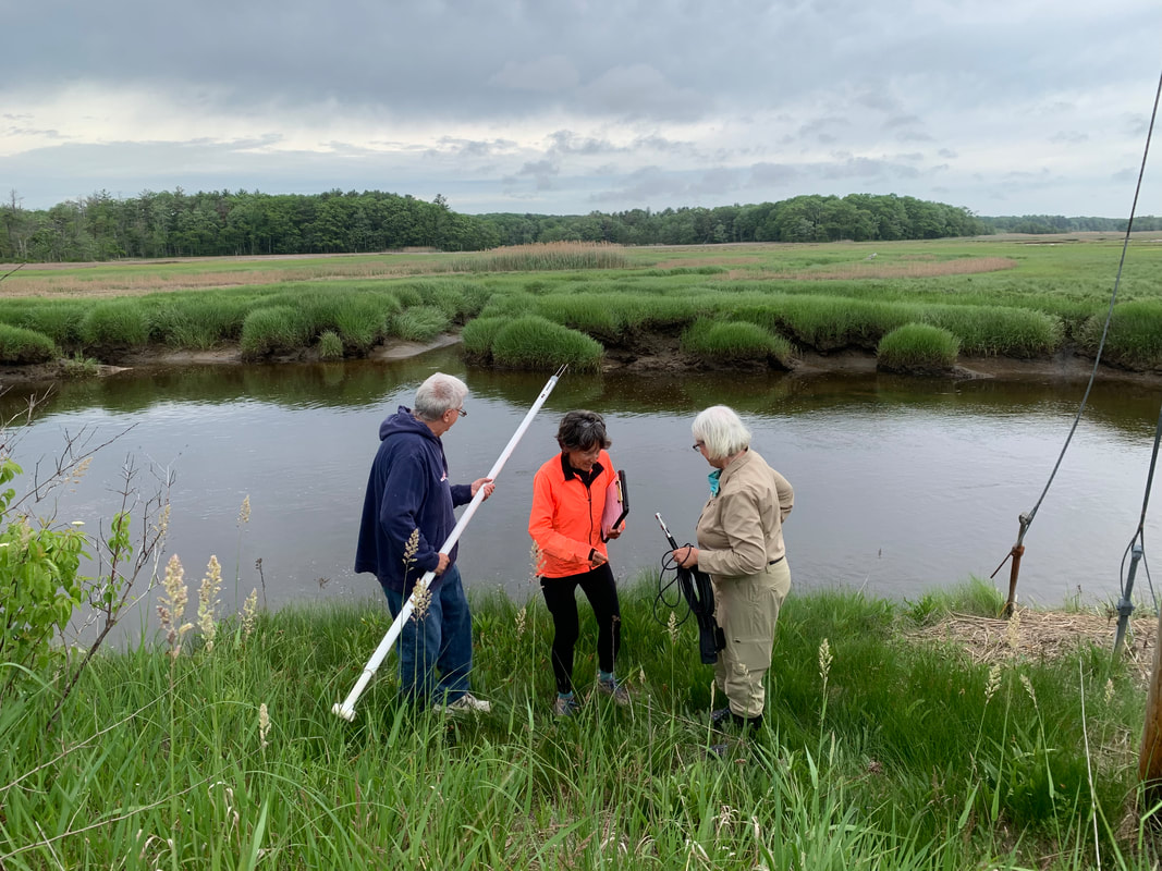
Scarborough Marsh is the largest salt marsh area in Maine. How is our cherished marsh doing? What can we say about its health and its future? These are questions that volunteers Greg Bither, Don Salvatore, Sue Williams and Betsy Barrett are helping to answer. Every two weeks they brave the mud, weather, slippery rocks, and road traffic of our marsh to gather data on its health.
The volunteers are part of the Maine DEP’s Volunteer River Monitoring Program (VRMP), which is a network of like-minded individuals throughout Maine who dedicate their time to gathering data on our rivers and streams. The statistics become part of the DEP’s database. In turn, the DEP looks at trends throughout the state, critically analyzes water body health, and makes recommendations about waterways that are in jeopardy and which need additional resources to ameliorate conditions.
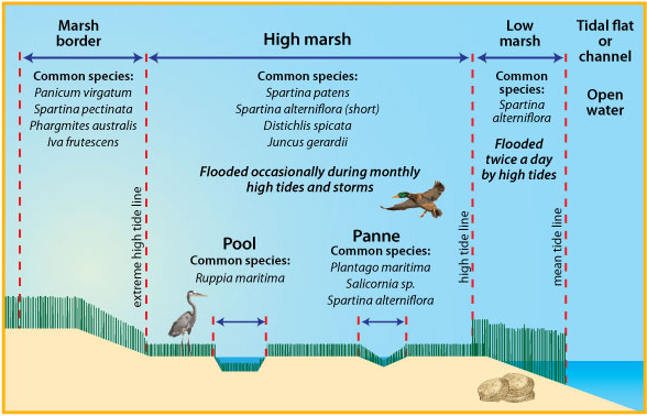
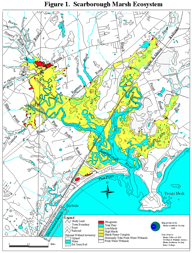
Every two weeks the volunteers, who are under the auspices of the Friends of Scarborough Marsh, visit eight rivers or streams which are tributaries to the marsh. They gather data on water temperature, bacteria content, conductivity (a measure of salinity as well as purity), and dissolved oxygen. They also make observations of water clarity, depth of flow, odor, turbidity, and a host of other measures. These indicators form a baseline for the health of the marsh. As time goes by, monitoring changes in these characteristics and looking for abnormalities in their numbers provides valuable information that will help in making decisions about future actions.
For now, many signs are positive. There are a few warning signs such as abnormally high bacterial contents in some tributaries, which have been previously identified and studied. However, the marsh is generally healthy, and most of the waterways are not in a dangerous category. Changes over time will best guide any future needs, and the efforts of this group will be sure to provide red flags when appropriate.
The volunteers are looking forward to a great year in 2023. They could use some help! If you are interested in spending a morning every two weeks or so in the marsh, please email Greg at:
greg.bither@gmail.com
The volunteers are part of the Maine DEP’s Volunteer River Monitoring Program (VRMP), which is a network of like-minded individuals throughout Maine who dedicate their time to gathering data on our rivers and streams. The statistics become part of the DEP’s database. In turn, the DEP looks at trends throughout the state, critically analyzes water body health, and makes recommendations about waterways that are in jeopardy and which need additional resources to ameliorate conditions.
Every two weeks the volunteers, who are under the auspices of the Friends of Scarborough Marsh, visit eight rivers or streams which are tributaries to the marsh. They gather data on water temperature, bacteria content, conductivity (a measure of salinity as well as purity), and dissolved oxygen. They also make observations of water clarity, depth of flow, odor, turbidity, and a host of other measures. These indicators form a baseline for the health of the marsh. As time goes by, monitoring changes in these characteristics and looking for abnormalities in their numbers provides valuable information that will help in making decisions about future actions.
For now, many signs are positive. There are a few warning signs such as abnormally high bacterial contents in some tributaries, which have been previously identified and studied. However, the marsh is generally healthy, and most of the waterways are not in a dangerous category. Changes over time will best guide any future needs, and the efforts of this group will be sure to provide red flags when appropriate.
The volunteers are looking forward to a great year in 2023. They could use some help! If you are interested in spending a morning every two weeks or so in the marsh, please email Greg at:
greg.bither@gmail.com
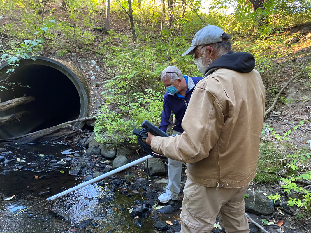
Photo: Greg Bither Board member and Volunteer Don Salvatore working at Millbrook site above
Photo: Greg Bither, Betsy Barrett and Sue Williams working on Black Point Road site top photo
See our final report for 2022 under our Projects Section
Links to DEP research site:
Link to maps: maine.maps.arcgis.com/apps/dashboards/0ca4fbd9c7584fbd9c2c56ef5413a915
Link to VRMP data: www.maine.gov/dep/water/monitoring/rivers_and_streams/vrmp/reports.html


 RSS Feed