FRIENDS OF SCARBOROUGH MARSH
  • Home
  • News
  • About
  • VISIT
    • Photo Gallery
    • Gervais marsh tower
    • Blue Point Preserve
    • Audubon Marsh Center
    • Map of Scarborough Marsh
    • Tide Chart
    • Virtual Tour of the Marsh
  • EDUCATION
    • Lectures
    • Virtual Tour of the Marsh
    • Watershed
    • Healthy Yards and Marsh
    • Treasure
    • Phragmites
    • Marsh Wildlife ID Card
  • PROJECTS
    • Project News
    • Our Work
    • Conservation
    • Restoration

conservation Project news

Salt Marsh Vegetation ZONES

5/9/2012

 
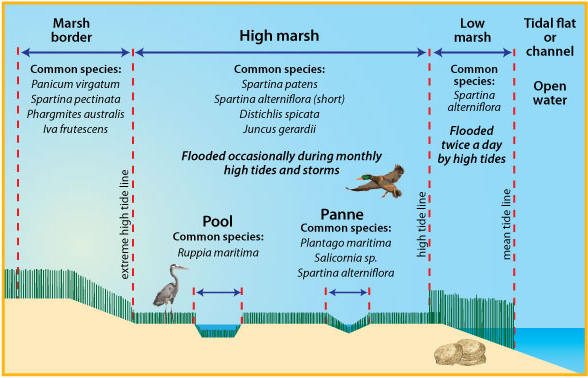
With thanks to Maine Sea Grant program for this image; please visit their site for more info.
Picture

MAPS

5/6/2012

 
Base Map, Scarborough Marsh Strategic Plan (2002)

Scarborough Marsh Watershed (Maine Audubon, 1999)

Map of Conserved Lands, Scarborough, Maine

Scarborough Marsh Drainage Areas
Picture
Aerial View of the Scarborough Marsh (with restoration project sites)

The Need for Restoration

5/6/2012

 
Scarborough Marsh: The Need for Restoration  
Protection & Restoration Strategy for the Scarborough Marsh Watershed (Prepared for Friends of Scarborough Marsh by Normandeau Associates, Inc. and Terence J. Dewan & Associates. 2002)
The Scarborough Marsh: Historical Impacts, Current Conditions, and Restoration Potential (Maine Audubon. 1999)   This is the report that started it all! Shortly after the publication of Maine Audubon's report in 1999, a small group of concerned citizens and representatives from partner groups took the first steps to form the Friends of Scarborough Marsh.
Flooding and Erosion of Maine's Coastal Wetlands (Maine Sea Grant)

Mill brook water quality study

5/2/2012

 
Picture
The Friends of the Scarborough Marsh (FOSM) has completed an eight month water quality study of Mill Brook, a tributary of the Nonesuch River. The project, focusing on a 1.7 mile stretch of the creek running from Sawyer Road, under US Rte 1 to the Eastern Trail, aimed to identify constraints the town faces in improving water quality to levels that would permit reopening clam flats for harvest. Overall, water quality was good, with one major exception: coliform bacteria rated as poor at all four sampling sites during every month except January, 2012. 


    REPORTS, UPDATES, STUdies, & MAPS

    A library of reports and resources.

    Picture

    BROWSE BY Categories

    All
    Fact Sheets
    FSM Progress Reports
    INDEX
    Maps
    Restoration
    Salt Marshes
    Water Quality
    Wildlife

    BROWSE BY DATE

    January 2022
    October 2020
    November 2017
    May 2014
    May 2013
    May 2012
    May 2010
    May 2009
    November 2008
    May 2008
    May 2007
    May 2006
    May 2004
    May 2002
    May 2001
    May 2000
    May 1999

    RSS Feed

Picture
DONATE

Volunteer

About  

 Contact

       KEEP IN TOUCH:
© COPYRIGHT 2015. ALL RIGHTS RESERVED.